The task area is the area available for a task. This may be constrained by geography, by controlled or restricted airspace, and by the distance it is practical to fly.
You will need to consider the terrain in the task area. Terrain will affect where the lift is concentrated, and the landout options.
In many parts of New Zealand you may have mountain ranges to cross. These can be great lift concentrators, but they can also be large obstacles. Crossing a range can make retrieving difficult as roads tend to go the long way around mountains. If the thermal tops are above the mountain tops, mountains are helpful. If the thermal tops are below the mountain tops, mountain ranges are obstacles.
Mountain ranges and large valleys often seperate weather systems. It is common in New Zealand for the west coast weather to be very different to the east coast weather. Microclimates in large valleys can differ from the overall weather.
Valleys can funnel the local surface winds, often creating convergences.
Airspace may be a restriction. If you don't have a transponder you'll need to avoid controlled airspace. Some airspace is difficult to get a clearance through, so you may want to avoid anyway.
The distance it is practical to fly in the time available will set the outer boundry of the task area. The available soaring window can be guessed from the weather forecast and from experience. If you think the thermals will be starting around midday and shutting down around 6pm, then you've a six hour window. Estimate the cross country speed you think you can achieve, multiply by the time available, and halve that. That's the maximum distance you can go and get back from. You may not want to use all of the area, but that's the limit of what is practical.
If you have specific task requirements the task area may be smaller. For example if planning a Silver distance, your task area is a 50km radius around the release point.
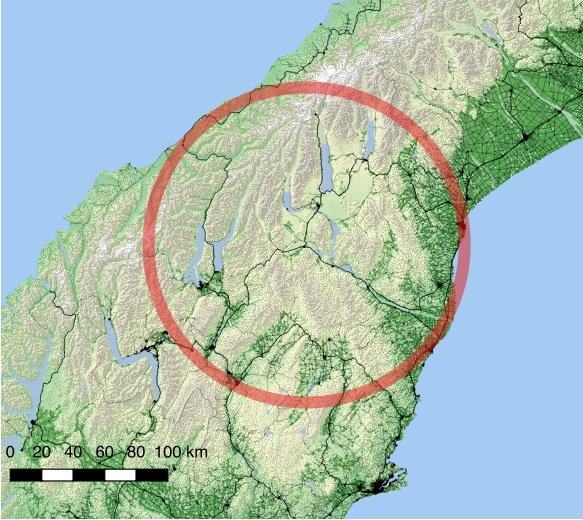
To help visualise the task area, get a current chart of the area you expect to fly. Draw a circle around your site out to the distance you've just estimated.
If you use electronic flight planning software, set a waypoint centered on your site with a radius of your maximum task distance.
Another option on the computer is to use Google Earth. Zoom to the area you are expecting to use and use the measure tool to see what the task area looks like over the map.
This example shows a 100km radius around Omarama.
You should task in areas where there are usable landing options. In some areas these are mostly airfields/airstrips, and in some areas there are plenty of landable paddocks etc.
The distance the task can be from these landing areas depends on the height you're expecting to operate at. If you have a 3,000ft cloudbase you need to be close to a landable field, but if you're operating above 5,000ft mountains you can easily be 40km from your landing area and still be operating with a comfortable margin.
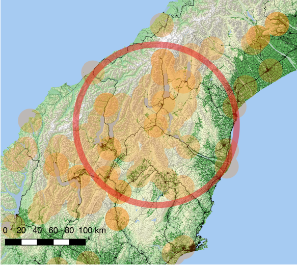
To help visualise where you can fly while keeping a good landing option available, draw range rings around each landable point. Where the rings overlap is the possible landable routes that it makes sense to use for tasking.
This example from Omarama shows 15km circles shaded orange centered on airfields and airstrips in the Omarama database.
Any task area will have soarable routes, areas where lift is likely to be, energy lines above ridges, good thermal sources, etc. These will vary with the weather on the day, but will tend to be the good places to be.
Most of these soarable routes will be well known to the experienced cross country pilots who have flown in an area, so one way of finding out what the good soarable routes are in an area is to ask the locals.
Using the RASP forecasts and looking in particular at the thermalling height, thermal updraft velocity, and boundry layer max up/down, will give a good idea of where the lift is going to be concentrated on a thermal day.
On a wave day the upper level forecasts of vertical velocity will show where the wave is expected and the strength. Also look at boundry layer cloud cover and cumulus cloudbase to see if there are likely to be gaps to run in.
If ridge is likely, look at the surface winds to see if there is likely to be good wind strength and direction on the ridgetops. Check cumulus cloudbase to make sure there is enough room between the top of the ridge and the bottom of the cloud.