
This work is licensed under a Creative Commons Attribution 4.0 International License
Also known as atmospheric gravity waves, mountain lee wave often forms on the lee of the Southern Alps. We often see a distinctive northwest arch cloud formation.
There are plenty of explanations of wave in gliding books. Power flying descriptions and meterology papers are also plentiful.
For usable wave we normally need 15 knots or more wind blowing over the trigger. Like a ridge, the wave works best with the wind perpendicular to the trigger, but it can be as much as 45° off and still make useable lift.
It is best if the wind speed increases with altitude. If the windspeed doesn't increase with altitude the wave tends not to propagate upward.
The prevailing wind over the South Island is from the west and the weather systems often provide plenty of strong winds that favor lee wave production.
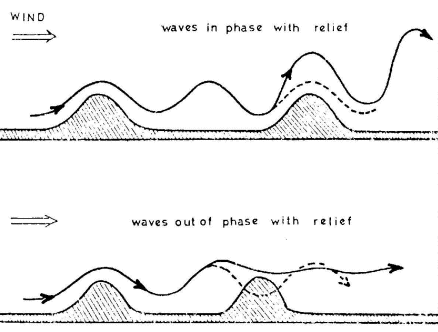
Something is required to lift the air to start the wave. A decent mountain or mountain range is good. The South Island Main Divide is a mostly unbroken range of mountains from Fiordland to Marlborough. Over 500km of excellent trigger.
The shape of the trigger is significant. The upwind face doesn't matter much, the lee face is the important bit. A good drop off is best. As the Southern Alps are relatively young and haven't been worn down much they are steep. We have plenty of steep lee faces to really give the wave extra kick.
The atmosphere, particularly the upper atmosphere, needs to be stable for wave to form. Air coming from the ocean is cool and stable compared to air over a large landmass. In the South Island we have the prevailing westerly flow coming from the Southern Ocean or the Tasman Sea providing a continous supply of stable air.
On the lee of the Southern Alps we have large valleys and basins that are sheltered and get warmed by the sun from early morning to produce the unstable low level airmass that helps the wave to really pop.
When these conditions are met, mountain lee wave forms in bands downwind of the trigger and parallel to the trigger. If the stability is good above the inversion and unstable below the inversion the wave can oscillate creating parallel bands downwind. These can propagate downwind 10, 20, 30 bounces in ideal conditions. You often see this visible in satellite pictures.
The gap between these wave lines (the wavelength) is directly related to the wind speed. Roughly divide the windspeed by 5 or 6 to get the wavelength. So 30 knot winds gives wavelengths of 5 or 6 nautical miles. Double the windspeed to 60 knots and the wavelength doubles to 10 or 12 miles.
If there is terrain interfering with the lower level wave, it can reinforce or reduce the wave system.
The windspeed changes with altitude and location, so these are just rule of thumb numbers. The stability of the atmosphere also affects wavelength to a lesser degree.
If you read a few of those academic papers about lee wave you'll understand that the atmosphere is complicated. There are some adequate rules of thumb we can use to build a simple model of the wave that is accurate enough to be useable for the purpose of soaring.
The wave forms in lines parallel to the mountain ranges, downwind of the mountains. Generally the first bounce (often refered to as the 'primary') is the strongest. The wave may oscillate downwind causing more parallel wave bars.
If the wave is marked with cloud and the wave well defined, these wave lines are easy to see. This is not always the case so you must imagine where the wave is and fly based on that model.
The low level wave cloud (rotor cumulus) marks the top of the unstable thermic layer beneath the wave. Above that is the stable laminar flow of the wave. The usable wave lift is upwind of the cloud.
Beneath the rotor cumulus is the rotor in the unstable lower airmass. When the lower airmass in unstable and the winds strong the rotor can violently energetic. This animation of wave formation in deep water shows the mechanism for generating rotor.
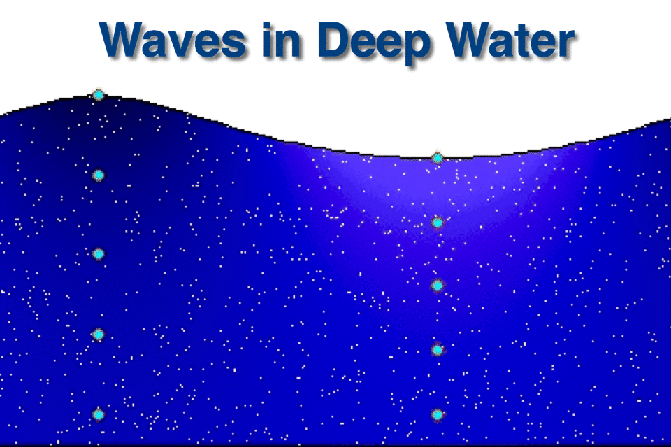
Lee wave is a standing wave, so unlike the water where the water is mostly stationary and the wave moves, in lee wave the air moves and the wave stays in the same place. The vertical oscillation in the moving air creates a rotation that propogates down, rolling the thermals. They tend to break up into bubbles, rising and rotating.
The wave lines are regularly spaced, often with the exception of the first (primary) wave line. The first wave line is often triggered from a hydraulic jump occurring on the lee slope of the mountain range that we think of as the trigger. This is often very close to the mountains. The wave oscillations downwind will be regularly spaced.
The horizontal view of the wave is a series of lines of sink and lift parallel with the back edge of the mountain range upwind. If marked with cloud, the cloud line has lift upwind and sink downwind.
The vertical view has rotor thermal below the wave, going up strongly where the wave is lifting and being suppressed where the wave is dumping. Above this turbulent, unstable layer is the stable laminar flow of the wave.
The laminar flow of the wave, the good bit that can be used to go places, can be tricky to get into. There are a number of common techniques. You work your way to the upwind edge of the rotor cumulus and climb into the smooth laminar flow upwind of the cloud.
Some people call this cheating. Some days it is the only way.
This generally requires a high tow to the front of the rotor. It's not unusual to tow to 3,000 or 4,000 feet AGL to contact the rotor. Mostly because you need to tow upwind to where the rotor is. If you don't get a climb quickly, you'll probably need to land and try again.
At Omarama we most often have unstable air under the wave and we can climb up in the rotor. This can be an effective way of getting into the wave, but has its problems.
The best lift is generally towards the upwind edge of the rotor cumulus. You must position the glider under the upwind edge of the rotor cumulus and find a rotor thermal to climb up to cloudbase.
Rotor thermals are not structured like flatland thermals and if you try to center them like flatland thermals you're likely to lose the lift. Once you're in the sink you'll quickly need to land.
If there is a handy ridge, you can climb on the ridge and push upwind to work a rotor thermal into the wave. If that fails you can drop back onto the ridge to try again.
The best ridge is one that is oblique to the wave line. This allows you to work along the ridge into a better situation under the wave, then push upwind at the prime spot for an easy entry.
When working rotor thermal, they are called rotor because the thermal bubble is rotating in the windshear. As the bubble rises into increasing wind the top is rolled. The upwind side of the bubble is going up with the bubble and with the rotation. The downwind side is going up with the bubble, but less as it is on the down side of the rotation. This means the strongest part of the thermal is not the center, but the upwind edge. Upwind of that is the down between the thermals, so the shear can be vicious.
As the bubbles rise into increasing wind the wind blows around the bubble, causing a windshear at the side of the bubble. When you try to circle and leave the bubble, passing into the windshear, you can get a big surge on the vario. If you're going upwind this is a little lift and a lot of gust. Turning downwind at the edge gets huge sink on the vario. Again, this is a little sink and a lot of horizontal gust.
Rotor thermal is very dynamic. You can't process information and then act, you're long gone from the lift by then. You must turn on the feel, turn tight. There are no style points in rotor, you only get points for staying in the lift. Same for speed. You must fly fast to get out of the sink and slow to stay in the lift. If you wait for the vario you will be behind the action. Fly the feel. Unload (push) when you feel the glider sinking, load up (pull) when you feel it lifting. Keep the attitude correct and the instruments will catch up later.
In weak smooth lift react smoothly and gently. In turbulent powerful rotor react promptly and firmly. Don't thrash the controls. Remember that the reason they fit control stops is to give you somewhere to rest the stick while you wait to see if the glider is going to do what you asked it.
Circling is best, but sometimes you just can't turn in the lift. Every time you turn you fall back into the sink. If this happens, try 'S' turns to stay in place over the ground. You're trying to work the front edge of the thermal where the lift is strongest. The stronger the wind, the less exaggerated the 'S'. In very strong wind you can just fly into wind and pull up in the lift. Getting slow here is high risk though. If you fly out of the lift at 40 knots into 1,000ft/min sink you'll lose a lot keeping the glider flying and getting back to the lift.
For all this to work, you must be in the right place, doing the right things, at the right time.
The right place can be identified by the cloud formations, or the proximity to the terrain trigger and wind direction, or by the other gliders climbing away. You can generally tell if you've found the right place, because even if you're not climbing you're hanging in there. If its the wrong place you'll be going down and running away fast. If it is the right place and you do the right things, then its just a case of waiting for the right time. Sometimes this can take a while.
Remember the three 'P's of wave flying. Patience, Perseverance, and Persistence.
Once you're above the unstable lower flow, turn across wind and fly fast. Allow enough offset for drift. If you lose the lift it is most likely because you've drifted downwind. Turn upwind to reconnect and then fly with more offset for drift. Always stay upwind of the cloud.
Wave systems are big. Once you're in the wave you need to fly the big picture, not chase every wisp. Look along the line you want to run and watch your drift. If you're always near forming cloud you need to go more upwind. If you're in sink you probably need to move upwind. Fly fast.
Briefing prepared by Phil Plane.
This work is licensed under a Creative Commons Attribution 4.0 International License